There are three and a half major plausible theories on what happened to Amelia Earhart and her navigator Fred Noonan, when they disappeared on 2 July 1937: 1. They were captured as spies by the Japanese in the Marshall Islands, and died or were executed in captivity there or on Saipan; 2. Unable to find their tiny destination of Howland Island, they turned SSE and landed and survived for a while on Nikumaroro (“Niku”) atoll in what is now the Republic of Kiribati; 3. Having run out of gas, they crashed into the Pacific near Howland; and 3.5. They crashed in the ocean on a line between Howland and Niku.
My research indicates that the Marshall Islands theory is possible but unlikely. There is no credible supporting physical evidence. The Marshalls are far off Earhart’s direct route from New Guinea to Howland. There was a 1943 fictional movie, “Flight for Freedom,” which convinced WW II GIs (and indirectly the island natives) that Earhart flew over, spied on, and crashed in the Marshalls. There is no credible witness who saw Earhart or a photo of her before 1937, and identified the same woman in the Marshalls or Saipan in 1937 or later. (A few islanders did say that they saw a captive “tall white woman,” but that is quite different.) By contrast, I have found at least two major instances where an irrelevant or barely relevant item was exaggerated over time into false “absolute proof” that Earhart was captured.
The International Group for Historic Aircraft Recovery (TIGHAR), of which I am a member, has researched the case for over 30 years, and has assembled considerable physical evidence (but not complete proof) for Nikumaroro. Recently, however, some evidence has weakened. An old sextant box found on Niku, which plausibly belonged to Fred Noonan, has now been traced to a US Navy vessel. Two TIGHAR/National Geographic Society expeditions to Niku (one of which I participated in) using forensic dogs, showed that a castaway (quite possibly Earhart) did die under a large “Ren” tree on the SE corner of the island. But extensive recent efforts failed to extract human DNA from the tree, coral and soil at the site (yes, human and Neanderthal DNA up to thousands of years old can now sometimes be extracted from soil). Bone measurements of a skeleton found on Niku but now lost, which the top forensic anthropologist in the US believed were likely Earhart’s, have recently been shown to have possibly come from a crew member of the freighter Norwich City, wrecked on Niku in 1929. And in 2019 the famous explorer Bob Ballard searched underwater all around Niku, down to a depth of 5,000 feet, and found nothing. (But Ballard did not search down to the 13,000-foot sea floor, or out beyond the base of the island to the northwest near the likely landing area – as I think he should have.)
The “splash-crash near Howland” theory has been extensively researched. But seven expeditions by various groups, over a period of 35 years, spending over $30 million, have failed to yield a single piece of evidence. Those expeditions mapped an area the size of Connecticut around Howland to a depth of 14,000+ feet, to one-meter resolution. The area is one of the best-mapped underwater locations on the planet! But no piece of Earhart’s Lockheed Electra 10-E has been found.
My variation on the usual “Howland splash-crash” theory is that Earhart and Noonan failed to find tiny Howland, turned SSE, and crashed far from Howland. This is supported by Amelia’s last radio transmission: “We must be on you, but cannot see you…we are flying on the line 157 337.” Earhart knew that flying NNW on the compass heading 337 degrees there was nothing but ocean until hitting Russia, 3300 nautical miles away. But by flying SSE on 157 degrees, she could possibly reach the Phoenix Islands, including Niku, before running out of gas.
Researching my sub-theory requires looking along the 350-nautical mile underwater corridor between Howland and Niku. No-one has done that. Luckily, Bob Ballard has recently been given a contract to map and document the large US-controlled ocean bottom around Howland, and I understand that at least a partial corridor search will be undertaken. And the USN Underwater Archaeology Branch has just taught a computer to recognize shipwrecks on the ocean bottom with 92% accuracy, using artificial intelligence, from surface scans. While this has only been done in shallow water (279 feet) to date, this depth could be dramatically increased by deep diving Autonomous Underwater Vehicles. Fingers crossed.
Next week I will describe some bizarre Earhart theories and some new minor plausible ones, tell you how you can get involved in the search, and give you my probabilistic predictions on where to find her.
Good hunting!
Photos courtesy Lew Toulmin
-

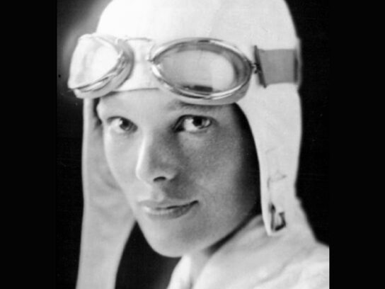
- A. Amelia Earhart, the “First Lady of the Air,” and for a decade before her disappearance likely the most famous woman in the world.
-

- B. Patch/logo for the TIGHAR/National Geographic Society expedition to Niku that the author participated in, with seven certified archaeologists, four Border Collie historic human remains detection (HHRD) dogs, and 30 human volunteers. One of the four dogs is on the right, Amelia is on the left, and uninhabited Niku atoll is in the center.
-

- C. A map of the South Pacific, showing Earhart’s departure point in Lae, New Guinea, her destination of tiny Howland island, Nikumaroro to the south, and the Marshall Islands to the northwest. Her next leg on her historic round-the-Equator flight would have taken her and navigator Fred Noonan to Hawaii, shown in the upper right of the map.
-

- D. A rare American freckle jar found on Niku (right), with a box (left) from the likely manufacturer. Earhart hated her freckles and used this type of mercury-based crème. This is one of many similar bits of evidence supporting the Niku theory.
-

- E. Author Lew Toulmin (right) of Silver Spring and Arthur Rypinski of Rockville on Niku, screening and sorting through tens of thousands of small pieces of coral, each of which looks remarkably like a human bone.
-

- F. The 1937 search for Earhart focused to the NW of her destination, Howland island, as shown by the lavender area on this map. The only search of Niku (then known as Gardner Island) was done by three floatplanes (upper right) from the USS Colorado. Look at the area around Gardner Island in the lower right of the map — the thin reddish line shows the path of the Colorado offshore, and the thicker pink line shows the path of the float planes. The aerial so-called “search” took place a week after the disappearance. The three planes flew at about 90 knots and 500 feet in the air, “zooming” for 18 minutes over four-mile-long Niku. One pilot reported seeing “signs of human habitation” – but there had been no such habitation since the 1890s! What exactly did he see? No follow-up or ground searching was done.
-

- G. The Republic of the Marshall Islands (RMI) is so convinced that Earhart and Noonan crashed on Mili Atoll in the Marshalls, that the RMI post office issued stamps in 1988 showing and “proving” the incident. The Japanese freighter Koshu also allegedly recovered the Electra during WW II, largely intact, as seen on the ship’s stern on the right – but in fact the plane has never surfaced.
-

- H. Four forensic dogs and their handlers on Niku. The dogs can detect the smell of human remains hundreds of years old, and even the scent of cadavers under water. The dogs’ jackets provide sun protection, high visibility in thick brush, and evaporative water cooling in Niku’s high heat and humidity. Even with this protection, they could only work for 20-50 minutes at a stretch, compared to 4-5 hours in cool climates.
-

- I. What seems to be a ray from heaven points down to uninhabited Niku atoll, perhaps saying, “Search here!”


Comments are closed.