Recall from last month’s column that in the spring of 2024 my wife and I drove through 500 miles of fabulous parks in southern Utah. The second leg of our drive took us on Utah Route 12 (an “All American Road” rated as one of the “best drives in the West”) from the town of Torrey to Bryce Canyon City through Capitol Reef National Park (NP), Escalante National Monument, Kodachrome Basin State Park and Bryce Canyon NP.
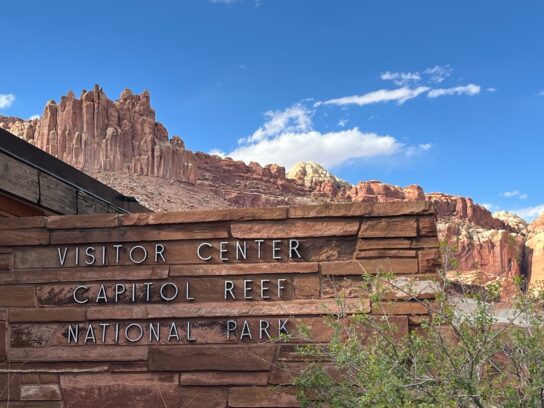
Capitol Reef NP is a long, narrow park with 377 square miles surrounding the Waterpocket Fold, a strange wrinkle in the Earth that extends for 100 miles from north to south, which reaches heights of 11,000 feet. The “reef” name comes from early travelers who found the massive wrinkle to be a navigational hazard similar to a reef at sea. The “capitol” name derives from the white domes of rock atop the reef. We drove an 8-mile paved scenic drive that gave us a taste of the area, and later saw Panorama Point, which provided a terrific 360-degree view of massive sandstone cliffs.
Escalante surprised us with its long official name of Grand Staircase/Escalante National Monument, and its land area of over 2900 square miles – larger than Delaware and DC combined! It was not well marked as we entered, and we did not realize how huge it was, so we were 40 miles in before we realized we had been inside the Monument for over an hour.
We should have figured out that we were on public land, since we had recently learned that over 70 percent of Utah is owned by the Federal or Utah governments.
Astoundingly, this part of the US was just a huge blank on the map until 1876, when little-known explorer Almon H. Thompson completed his historic four-year mapping survey of southern Utah. Thompson named the area after two Spanish priests, Fathers Escalante and Dominguez, who in 1776 attempted a grueling expedition from Santa Fe to California. Although they never made it to California, they explored huge areas of Colorado and Utah, and provided the first Western glimpse into this massive region.
Our highlights in Escalante were 6000-year-old Indian petroglyphs showing animals on rock faces just off the road, and Scenic Route 12, which had terrific views at every turn.
Kodachrome Basin State Park was one of several state parks we visited, and we found them to be just as attractive and much less crowded than the National Parks in the area. We enjoyed views of some of the parks’ 67 stone spires, called sedimentary pipes, which have slowly formed over 180 million years. Geologists are still debating exactly how they were created.
The park’s unusual name came from a National Geographic Society expedition in 1949, whose participants were impressed with the beautiful red spires contrasting with the baby blue skies beyond. They named the park for the wildly successful color film introduced by Eastman Kodak in 1935.
Like most of the national and state parks we visited, Kodachrome has a mixture of scenic paved and gravel roads, hiking trails, mountain biking trails, campsites, a visitor’s center, bathrooms, and various activities such as archery, horseback riding and dark sky star gazing. Our Federal senior Golden Age pass did not help us in this state park, so we paid a day use entry fee of $10 for our vehicle.
Bryce Canyon NP was our favorite park of this leg of the trip, even though at only 56 square miles the park is 50 times smaller than Escalante. We were expecting another park full of canyons, but instead were astounded by the twelve semi-circular “amphitheaters” of bizarre formations that we could see down into from our ridgeline above. The park bills itself as having “the biggest concentration of hoodoos on Earth,” and we don’t doubt it. But these hoodoos are different from the hoodoos of Goblin Valley State Park, which I described last month. These hoodoos usually are grouped together like saw teeth, while the Goblin hoodoos generally stand alone.
Like many National Parks in Utah, there is a dead-end paved road that takes you to the best lookouts and sights in the park. This one is 18 miles long, and if you stop at every lookout you can take at least four to six hours to see everything. At the south end of the road, on a clear day, you can see the San Francisco Peaks, 150 miles away!
The National Park Service runs a bus shuttle service into the park, but we found that in April there were just enough spots for us to park at each lookout. In more crowded months it might be wise to take the shuttle from the town north of the park. Bryce is so popular that it attracts 2.7 million visitors per year!
Strenuous hiking trails drop down from the overlook ridge into the hoodoos below, or a flatter trail runs beside the paved road, along the ridgeline edge of the amphitheaters and lookouts.
Other activities in Bryce include stargazing with ranger assistance in one of the darkest skies in the US, horseback riding, mountain biking, bird watching, photography (especially during the morning and evening “golden hours”), camping, picnicking, overnight stays at the rustic Park Lodge, and a Prairie Dog Festival.
Oddly, Bryce Canyon is not really a canyon, since canyons are cut by rivers and Bryce was carved by millions of years of weathering of the chromatic limestone of the Paunsaugunt Plateau.
The Bryce name comes from Ebenezer Bryce, an 1860s Mormon settler and ship’s carpenter who lived in the area and built the Pine Valley Chapel in 1868 roughly in the form of an upside-down ship – it is the oldest continuously used Mormon church in existence.
Although there was snow still hidden on the north side of many Bryce Canyon features, we found that our late April and early May visit to southern Utah gave us perfect weather, with cool mornings and mildly warm afternoons. Only one of our nine days was rainy and cloudy, so on sunny days we were grateful for our wide brimmed hats, sunglasses and sunscreen. Years ago, we brought heavy SLR cameras on our trips to capture the beautiful scenery, but now we just use our iPhones for photography, saving a lot of weight.
Next month we will complete our journey southwest through the incredible parks of southern Utah.
Photos courtesy Lew Toulmin
-

- A. The 100-mile-long Reef looms over the Capitol Reef National Park Visitor Center in southern Utah.
-

- B. The strange Waterpocket Fold, a massive wrinkle in the Earth, created huge cliffs that were an obstacle to early settlers traveling in wagons. With our paved roads, we have it pretty easy!
-

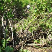
- C. A 6000-year-old Indian petroglyph just off Utah’s Scenic Route 12, one of the most beautiful roads in the state. What can you see?
-

- D. All the National Parks have a silly rule prohibiting off-road driving – what a Nanny Society!
-

- E. Our hotel room in Torrey, Utah came with a rubber duck that we ducknapped and naturally named Torrey. (We were jealous of all those Jeeps festooned with a row of ducks across the dash.) Here Torrey is smiling about the phallus-shaped, 180-million-year-old pinnacle in the distance at Kodachrome Basin State Park. The small banner on the window says, “No valuables in vehicle.”
-

- F. The north side of one of the dozen amphitheaters, with hundreds of hoodoos, in Bryce Canyon National Park.
-

- G. The south side of one of Bryce Canyon amphitheaters. The bright white line in the left center is a trail descending over 1000 feet to the bottom of the Canyon (which is not really a canyon!).
-

- H. An ominous black bird warns visitors of dangers in Bryce Canyon.
-

- I. A natural arch carved by wind and rain over millions of years in Bryce Canyon. Note the snow on the north slopes, still in place in late April.


Comments are closed.